
Drone inspection
Drone inspection: check roof, façade and plant without scaffolding and without downtime.
We fly buildings, roofs, façades and industrial plants from Zürich with a high-resolution camera and a radiometric thermal camera and deliver a prioritised findings list with photos, positions and, where needed, a measurable 3D model. Price range in two minutes, binding fixed-price quote to sign.
What is a drone inspection?
In a drone inspection, a drone photographs an object systematically from the air: every roof field, every façade side, every part of a plant from close range and several angles, with a thermal camera where useful. The images are evaluated on the computer and condensed into a findings list: what is conspicuous, exactly where, how urgent.
The difference to a walk-through: no scaffolding, no lift, no walking on the roof, no plant downtime. A single-family house takes half an hour, a commercial roof a morning. Findings are suspects your specialist checks specifically. We do not replace the roofer or the expert report; we show them where to look.
Areas of use
Depending on the object we fly visually, thermally or both. Solar plants have their own page with prices per plant size.
Roof inspection
- Tiles, sheet metal, flat roofs, junctions, chimneys, gutters. Damage after hail and storm, condition before purchase or renovation, recurring checks of large roofs without fall protection.
Building envelope and façade
- Cracks, spalling, damp patches, joints, windows and balconies in close-up. With thermal imaging: thermal bridges and leaks, visible when inside and outside differ in temperature.
Damage capture and evidence
- After fire, collapse, hail or storm we document the condition as photos and as a georeferenced 3D model in which every distance, area and height can be measured afterwards. Robust for insurers and assessors.
Industry and infrastructure
- Hall roofs, silos, masts, cranes, pipe bridges, noise barriers. Inspection during operation, without cordons and without work at height.
Solar plants
- Thermography of every single module with a findings list per module. Own page with process and prices. Go to solar thermography
What you get
Findings list
- Every finding with photo, position on the object, description and priority from “monitor” to “inspect urgently”. As PDF and as a table.
Full-resolution images
- All shots sorted by object part, with positions. For thermography, radiometric images with temperature per pixel.
3D model and orthophoto when it has to be measurable
- For damage capture, roof measurement and renovation planning we deliver the object as an RTK-georeferenced model; the accuracy achieved is stated in the processing report.
Download portal
- Available for one year, follow-up questions included, report in your layout on request.
Why drone instead of scaffolding
A walk-through needs scaffolding, a lift or rope access, hence time, cost and a safety risk. The drone sees the whole roof from above and at an angle, including spots unreachable from the ground and the ridge, and with the thermal camera it sees what the eye does not: moisture, thermal bridges, overheated components.
The shots are repeatable: on the next flight we photograph the same spots from the same position and you see what changed. For flat roofs, commercial properties and plants with maintenance duties this is the cheapest form of regular checking.
How a drone inspection works
Request
Object, number and location into the calculator: price range immediately, binding quote within 24 hours.
Preparation
Airspace and permits (federal drone map and DABS, clearances from Zürich Airport or Skyguide where needed, neighbours), flight plan per object, date. For thermography: a weather window with sun or a temperature difference.
Flight
Manual and automatic, from close range and several angles. A single-family house in 30 minutes, a commercial roof in a morning, no downtime.
Evaluation
Review of all images, findings marked and prioritised, thermography checked against the raw frames. 3D model where needed.
Delivery
Findings list, images and model within one to two weeks on the download portal.
Who benefits from drone inspection
- Property managers and owners — Condition of large roofs without scaffolding, plan renovations, document warranty cases.
- Insurers and assessors — Damage capture after hail, storm, fire as photos and a measurable model.
- Site managers and roofers — Measurement, acceptance, documentation before and after works.
- Industry and operators — Check halls, silos, masts, pipe bridges during operation.
- Buyers and architects — Condition before purchase or conversion, close-ups no ground photo delivers.
- Municipalities and utilities — Public buildings, bridges, noise barriers, works without cordons.
What does a drone inspection cost?
For inspections the number and complexity of objects count, not the area: one roof, a small tour of two to five objects, or a commercial park with more than six. The calculator gives you a price range in two minutes, evaluation included. Travel from Zürich, expenses only beyond 100 km. Solar thermography has its own fixed prices per plant size.
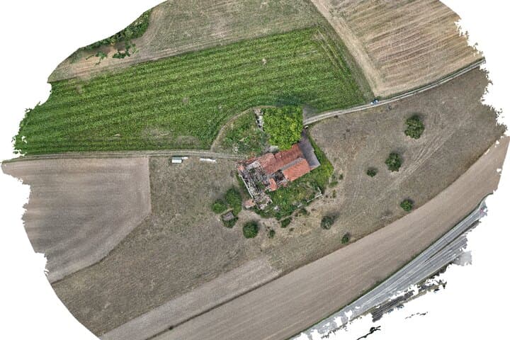
Example: collapsed farmhouse, damage capture in 7 minutes of flight
A collapsed farmhouse in the Swiss Mittelland, documented on 1 August 2026 with a DJI Matrice 4E: 482 photos at 1.3 cm ground resolution, flown at 50 m above ground around the building and over the surrounding land. Georeferenced by RTK, without ground control points. The result is a measurable 3D model with orthophoto in which insurer and assessor can take every distance, area and height afterwards. The showcase page shows the original data in the browser.
See the damage-capture showcaseFrequently asked questions about drone inspection
- Does a drone inspection replace the roofer or the expert report?
- No. We deliver the complete, documented view of the object and mark anomalies. Assessment and repair stay with the specialist; the expert writes the report, our data is their basis.
- What does the thermal camera see?
- Surface temperatures at about 0.1 K resolution: moisture in insulation, thermal bridges, leaking junctions, overheated components. This only shows with a temperature difference, so we schedule thermography flights by weather and time of day.
- May you fly over my building?
- Usually yes, with regard to neighbours, airspace and crowds. We check no-fly zones (Zürich airport, nature reserves) beforehand. We are registered with FOCA as an operator, the pilot holds the A2 remote pilot certificate, and liability cover is CHF 3 million.
- Does operation have to stop?
- No. We fly during operation, without cordons and without work at height. Only with people directly under the flight path do we agree the timing.
- How accurate is the 3D model?
- Ground resolution 1 to 3 cm. With RTK and no control points we expect 2 to 5 cm horizontally; height needs control points. Enough for measurement and damage capture; cadastral surveying stays with the licensed surveyor.
- How fast do I get the results?
- Flight by appointment, often within a few days. Findings list and images within one to two weeks, faster on request for damage capture.
Have your object inspected?
Price range in two minutes, binding fixed-price quote to sign. Or tell us what we should look at and we will come back with a date proposal.