
Knowledge · Fundamentals
What an orthophoto is, and when it is enough
Orthophotos explained: how they are built from drone images, what ground resolution and accuracy mean, when they suffice and when you need a 3D model.
Published · 7 min read · by Markus Linke
An orthophoto is an aerial image that has been rectified so that it has the same scale everywhere. You can measure distances and areas in it as you would in a plan, while still seeing what is actually on the ground: tracks, stockpiles, excavations, roof surfaces, services. For most tasks in construction, planning and agriculture, the orthophoto is the product that ends up on the table. This article explains how it is produced, what the figures in a quotation mean, and when you need a 3D model instead.
Why a single aerial photograph is not enough
Every photograph is a central projection: the camera looks at the ground from one point, and everything that stands higher is tilted outwards towards the edge of the image. A chimney stands upright in the centre of the image and leans at the edge. Distances are therefore only correct in the centre, and only on one plane. On top of that comes the relief: a slope facing the camera appears shorter than it is.
An orthophoto removes both effects. Every image point is computed back onto its true position on the ground, with the help of an elevation model that the software derives from the same images. The result is an orthogonal projection, that is, a vertical view from above onto every single point. That is why it is called an orthophoto.
How an orthophoto is produced from drone images
The drone flies the site in parallel lines and triggers the shutter often enough for neighbouring images to overlap heavily — depending on the terrain, 70 to over 90 per cent; on the landfill flight below it was 92 per cent along track and 85 per cent across. An area of seven hectares thus becomes a few hundred photographs; at finer resolution or over broken ground it quickly becomes a few thousand. The same spot appears on ten or more images from slightly different angles, and that is exactly what photogrammetry rests on:
- Image orientation — The software finds the same distinctive points in all images and computes from them where each camera stood and where it was pointing. How these steps work in detail is described in the article on photogrammetry.
- Point cloud — From the overlaps, a position in three dimensions is derived for millions of points. On the landfill from our showcase there were 384 million points.
- Elevation model — From the point cloud, a surface model (DSM, including structures and vegetation) and a terrain model (DTM, ground only) are computed.
- Orthophoto — Every photograph is projected onto the elevation model, the images are assembled into a seamless mosaic and stored in the national coordinate system.
The processing runs on our own hardware and is included in the price. You receive the finished product, not raw images.
Ground resolution: what the figure in the quotation means
The ground resolution (GSD, ground sampling distance) says how large one pixel is on the ground. At 1.6 cm ground resolution, one image point corresponds to a square of 1.6 by 1.6 centimetres on the ground. It depends on the flying height and the camera: flying lower means finer resolution, but more images and more flight time.
We fly at 1 to 3 cm ground resolution as standard. That is enough to identify kerbs, manhole covers and markings; clear cracks in a surface are visible in good light and contrast, but for assessing damage the close-up image remains the right tool. For an area overview of farmland or municipal territory, 5 cm is sufficient, and the area is flown more quickly. Finer than 1 cm is only needed if you want to assess individual components in detail, and in that case a drone inspection with oblique images is usually the better tool.
Accuracy: resolution is not positional accuracy
A common misunderstanding: a fine ground resolution does not automatically mean that the orthophoto is also in the right place. Resolution describes how much detail you see; positional accuracy describes how far a point in the orthophoto deviates from its true position in national coordinates.
Positional accuracy comes from the georeferencing. Our drones carry an RTK receiver that determines the position of each image to within a few centimetres; that is the accuracy of the camera positions, not automatically that of the finished orthophoto. For the RTK level without ground control points we commit to ±5 cm in position and ±10 cm in height in our quotation. The processing report of the landfill flight below states around 3 cm absolute — the expected value with an RTK fix, not the result of an independent check, because without ground control points there were also no check points. If you need a guaranteed ±2 cm in position and ±3 cm in height, you book the level with ground control points: we survey them with GNSS RTK and additionally place check points against which we verify the finished orthophoto. The deviations are then stated in the report.
As a rule of thumb: for as-built surveys, construction progress and area take-off, the RTK level is enough. For detailed design with tight tolerances, take the level with ground control points. For official cadastral survey, boundary questions or setting out, you need a patented engineer-surveyor (Ingenieur-Geometer); the orthophoto is then their working basis, not their replacement.
When the orthophoto is enough
- As-built survey before planning or conversion — What stands where, how large the areas are, where paths and services run.
- Construction progress — One flight per week or month, the same area, directly comparable.
- Take-off of areas — Surfacing, lawn, roof areas, car parks, all measurable in the orthophoto.
- Agriculture and municipalities — Parcels, tracks, trees, damage after a storm.
- Documentation and evidence — The condition on a given date, georeferenced and archivable.
When you need more
The orthophoto is flat. As soon as the third dimension matters, the other products of the same flight come into play:
- Volumes of stockpiles, excavation or a landfill: this needs the terrain model, see volume calculation.
- Heights and slopes of ground or roof: terrain model or surface model.
- Facades and undersides: an orthophoto only shows what is visible from above. Facades need oblique images and a 3D model.
- Planning in 3D: the textured 3D model or the point cloud that you carry on into CAD and BIM.
Orthophoto, terrain model, point cloud and the 3D model seen from above all come from the same vertical images: if you are unsure whether the orthophoto is enough, these products cost computing time, not a second deployment. Facades and undersides are the exception: they require additional oblique images, which we fly during the same deployment if you say so when you enquire.
Example: a landfill of 7.0 hectares
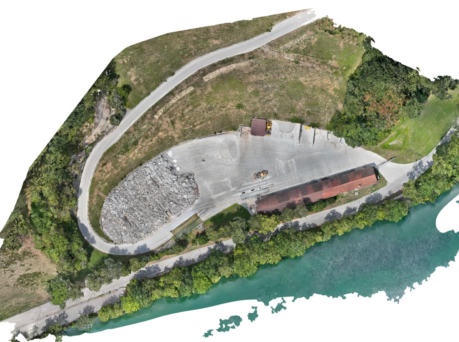
An active landfill on the Swiss Plateau, flown on 1 August 2026 with a DJI Matrice 4E: 443 photographs in seven minutes of flight time, 1.6 cm ground resolution, georeferencing by RTK without ground control points, around 3 cm absolute in the processing report. From this came the orthophoto, the point cloud, the terrain and surface models and the 3D model. In the showcase you can open the orthophoto in your browser and measure in it yourself.
What you receive
We deliver the orthophoto as a GeoTIFF in the national coordinate system LV95, so that it sits in the right place in QGIS, ArcGIS, AutoCAD Map and any GIS without conversion. On request additionally as map tiles for the browser or as a layer for your existing project; a PDF plan with a scale bar is possible on request depending on the project. Delivery normally within a week of the flight.
How a project runs and what it costs is set out on the drone surveying page; the calculator works out the range for your area in two minutes.
Frequently asked questions
- Is an orthophoto the same as an aerial photograph?
- No. An aerial photograph is a single image with perspective distortion: buildings lean outwards towards the edges, and distances are only roughly correct in the centre. An orthophoto is computed from many images, rectified and georeferenced, so that you can measure in it as you would in a plan.
- What ground resolution do I need?
- For construction planning, quantity take-off and as-built surveys, 1 to 3 cm per pixel is enough, and that is the range we fly as standard. For area overviews in agriculture or for municipalities, 5 cm is sufficient. Finer than 1 cm is only needed for detailed images of individual components.
- Can I measure heights in the orthophoto?
- No, the orthophoto is a two-dimensional map. Heights, volumes and slopes come from the terrain model or the 3D model, both of which are produced by the same flight.
- In what format do I receive the orthophoto?
- As a GeoTIFF in the Swiss national coordinate system LV95, on request additionally as map tiles for the browser; a PDF plan is possible on request depending on the project. You can open the GeoTIFF in QGIS, ArcGIS, AutoCAD Map or any GIS.