
Knowledge · Surveying
Volume calculation: accuracy and error
How a volume is derived from drone data, why the base surface decides the accuracy, and which sources of error distort the calculation.
Published · 6 min read · by Markus Linke
A volume is never a measurement, it is always a difference between two surfaces. That self-evident fact explains almost everything that can go wrong with volume calculations from drone data: the drone measures the upper surface very accurately. In most cases the lower one is an assumption.
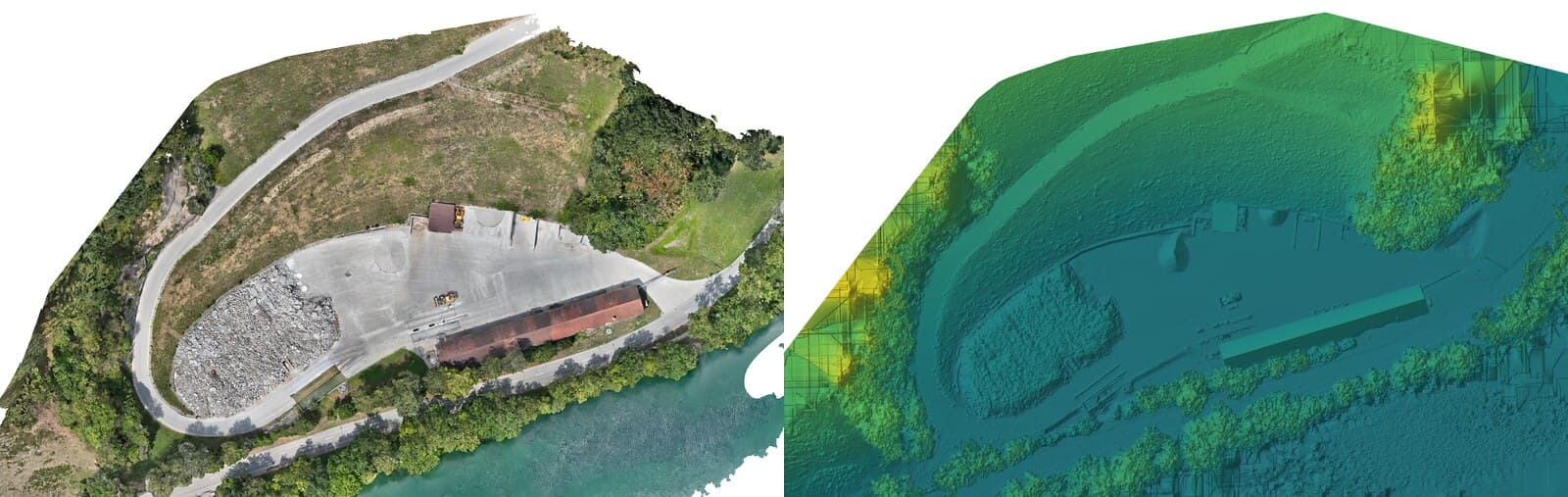
How the calculation works
The flight produces a terrain model, that is, a grid of height values. For each grid cell the software computes the height difference to the reference surface and multiplies it by the cell area. The sum over all cells is the volume. At a grid spacing of five centimetres that is four million individual values for one hectare, which explains why the shape of the stockpile hardly matters any more.
The only interesting question is which reference surface is used. There are three possibilities, and the choice belongs in the report:
- A plane or inclined surface beneath the material. Sensible when the stockpile lies on a made-up, level base and the toe is visible all round.
- An earlier terrain model of the same area. This is the normal case on construction sites and landfills: what has changed since the last flight?
- A design surface from the project, for instance the formation level of a planned excavation. This turns the comparison of design and actual state into a volume calculation.
The base surface is the largest error term
A worked figure that puts the proportions right. On one hectare, a systematic height error of a single centimetre corresponds to exactly one hundred cubic metres. On a landfill of seven hectares it would be seven hundred.
How accurately the drone knows the surface depends on the georeferencing. There are three routes to it: RTK corrects the position in flight, PPK computes it afterwards from the raw GNSS data, and surveyed ground control points tie the model in after the fact. None of these routes demonstrates the result; only check points do that, points deliberately kept out of the computation. The model cannot do better than the georeferencing allows. But where the ground lies beneath a ten-metre-high stockpile is something even the best georeferencing does not know. If a level surface is assumed there when the base actually has a hollow, that hollow goes straight into the result as an error. That is why the most important question before any volume calculation is not "how accurate is the drone" but "where does the base come from".
The best thing you can do: survey the area once before material is placed on it. On landfills and construction sites with recurring settlement, this first flight is the real investment; all the following ones are easy.
Why differences are more accurate than absolute values
For a volume calculation between two surveys, what counts is not absolute accuracy but repeatability. If both models sit too high by the same amount, that offset cancels out completely in the difference.
In practice that means: the same flying height, the same overlap, where possible the same ground control points, a similar time of day. We therefore plan follow-up flights as a repetition of the first and not as a new mission. Anyone who changes the parameters between two flights gives away precisely the advantage that makes difference measurements robust.
The other sources of error
- Vegetation. Ground classification separates growth from ground, but it can only separate what it sees. Under dense growth the surface is interpolated. On a vegetated heap that is a real contribution to the uncertainty; on a fresh gravel tip it is none.
- The delineation. Where does the stockpile end and where does the ground begin? With a gently running-out toe, a boundary drawn differently shifts the result noticeably. We set out the delineation openly in the report, so that it can be followed and repeated identically next time.
- Water and wet surfaces. Water surfaces do not reconstruct, wet mud reflects. Both create holes in the model that have to be filled.
- Movement during the flight. An excavator working during the survey leaves two different states in one model. On active landfills we therefore plan the flight into a quiet period.
- Overhangs. An elevation model knows exactly one height value per position. It does not represent an undercut working face; there you need the point cloud or the 3D model.
The factor that costs the most money
The most frequent discussion is not about centimetres but about bulking. The drone measures the volume as the material is lying at the moment of the flight. Loosening it increases the volume, placing it reduces it again. Depending on the material, the gap between the in-situ and the loosened state is roughly ten to forty per cent.
So anyone holding cubic metres from the drone model against delivery notes or skip counts is comparing two different quantities as long as the conversion factor is missing. That is not a weakness of the method, but it is the point at which a good measurement turns into a wrong calculation. We therefore always state in the report which state was measured.
What the report should contain
A volume figure without context is worthless. It only becomes verifiable with:
- the reference surface used and where it came from
- the delineation of the area evaluated
- the date, time and conditions of the survey
- the ground resolution and the grid spacing of the evaluation
- the areas in which the surface was interpolated rather than measured
- the measured state of the material
With that, the result can be checked and repeated identically next time. That is exactly the point: the value of recurring volume calculations lies in comparability, not in the single figure.
Where the boundary to the engineer-surveyor runs
For construction progress, mass balance, plausibility checks and your own control towards third parties, the drone evaluation is the right tool: fast, repeatable and independent. Whether it also underpins the settlement is a question of the contract and not of the law — that belongs settled before the work begins. For boundary questions and for documents of the official cadastral survey, the patented engineer-surveyor (Ingenieur-Geometer) is responsible; our data are then their working basis and not their replacement.
How a project runs and what the first flight costs is set out on the volume calculation page. How the terrain model on which the calculation is based is produced is explained in the article on photogrammetry.
Frequently asked questions
- How accurate is a volume calculation by drone?
- There is no blanket figure, because the uncertainty depends on the conditions: on the georeferencing (RTK, PPK or surveyed ground control points), on whether check points were measured, on vegetation and on the delineation. What accuracy the model can reach is capped by the georeferencing. Under good conditions — a free-standing stockpile, a visible toe, a made-up base, check points measured — the uncertainty is small compared with the quantity. The demonstrated value for your project is stated in the report, not on the website.
- Why are difference measurements more accurate than single measurements?
- Because systematic errors cancel out. If both flights sit too high by the same amount, that offset disappears completely in the difference. That is why comparing two surveys of the same site is more robust than a single absolute height measurement, and why we fly follow-up flights identically wherever possible.
- Does the calculated cubic metre match the one on the lorry?
- No. The drone measures the volume as the material is lying at that moment. Loosening it increases the volume, placing it compacts it again. Depending on the material, the gap between in-situ and loosened volume is roughly ten to forty per cent. Anyone comparing drone cubic metres with delivery notes has to know that factor, otherwise they are comparing two different quantities.
- Does this also work with vegetation on the heap?
- Only to a limited extent. Ground classification filters out sparse growth, but dense vegetation conceals the surface completely, and then the surface is interpolated rather than measured. On vegetated heaps we say so in advance and identify the affected areas in the report.
- Is this enough for settling accounts with the contractor?
- As an independent plausibility check and as the basis for a discussion: yes, and that is what it is mostly used for. Whether the figure also governs the settlement is decided by the contract: many works contracts allow a technical survey, others explicitly require a particular method or a particular firm. For boundary questions and for documents of the official cadastral survey there is no way round the patented engineer-surveyor (Ingenieur-Geometer); our data are then their basis.